
Sea Level and Pacific Islands
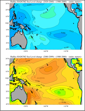
The projected sea level rise from the Pacific Islands Regional Assessment Group report (Figure 26) for the Hawaiian Islands during the period 2020-2040 (relative to 1980-2000) is 10.0 to 12.5 centimeters (3.94 to 4.92 inches) and for the period 2080-2099 (relative to 1980-2000) is between 35.0 and 37.5 centimeters (13.8 to 14.8 inches). In 1985, the State of Hawaii Coastal Zone Management Program and the Hawaii Institute of Geophysics, in response to Senate Resolution 137, compiled the report Effects on Hawaii of a worldwide rise in sea level induced by the “Greenhouse Effect”. The impetus, in part, for Senate Resolution 137 was due to wide ranging and thus controversial estimates from various studies on the projected range (70 centimeters to 600 centimeters or 28 to 236 inches) of sea level rise for the next century. The report’s purpose was to determine the significance of the range of Environmental Protection Agency predictions for sea level rise by 2100. These predictions were categorized as (a) lowest conceivable (0.57 meters or 1.9 feet), (c) lowest likely (1.5 meters or 4.8 feet), (c) highest likely (2.2 meters to 7.1 feet), and (d) highest conceivable (3.4 meters or 11.3 feet). It should be noted that presently most of projections of future sea level rise made in the 1980’s, in light of more recent estimates, are considered overestimates.
The report scenarios focused on rise of sea level impacts to Honolulu’s shoreline since this coastal city is both the state’s major population center and the transportation hub that the state economy depends on. The “lowest conceivable” Environmental Protection Agency estimate of sea level rise (0.57 meters or 1.9 feet) for 2100 is greater than the Pacific Islands Regional Assessment Group report projected sea level rise for 2080-2099 (0.350 to 0.375 meters or 1.15 to 1.23 feet; Figure 26), so it is difficult to extrapolate the report’s conclusions of this scenario to the Pacific Islands Regional Assessment Group projections. Figure 36 is a map of how a sea level rise of 0.57 meters (1.9 feet) would change Honolulu’s projected shoreline and flood hazard zone compared to the contemporary shoreline and flood hazard zone. In this scenario, only parts of Sand Island are inundated by sea level rise. However, Honolulu International Airport’s reef runway and greater areas of Waikiki are both projected as flood hazard zones with this elevation in sea level. Again, it is important to recognize that these projections and subsequent impacts were determined using the best estimates of the early 1980's, which is 25 years ago.
The economic and social impacts of changing climate on the Hawaiian Islands are intimately tied to changes in rainfall and sea level. Given that the state’s economy is heavily dependent upon the tourism industry (as of 2003, 26% of the state's economy is from tourism), any damage to the reef runway, which is used for landing and takeoffs of long-range heavy jets, and Waikiki could severely stress the state’s economy. Waikiki, one square mile of the total area of Honolulu, is associated with supporting 11% of the state’s civilian jobs, 12% of the state and local tax revenues, and is responsible for $3.6 billion or 46% of statewide tourism’s total contribution to the 2002 Gross State Product.
Figure 36. Projected impact to Honolulu shoreline of sea level rise of 56 centimeters (1.9 feet).
